Weather Services shares heat concerns for today, rest of the week
Published 7:32 am Wednesday, July 12, 2023

- The National Weather Service shared Heat Advisory/Excessive Heat Warning info for Wednesday. (Courtesy of the National Weather Service)
|
Getting your Trinity Audio player ready...
|
Dangerous heat is returning to the area, weather watchers warn.
High pressure aloft will build over the area the next several days, according to the National Weather Service.
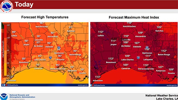
That National Weather Service shared forecasts for Wednesday’s High Temperatures and Maximum Heat Index.
This will mean less of a risk for severe weather and heavy rainfall, but unfortunately, oppressively hot conditions area returning, forecasters said.
Hazardous heat will continue across the area over the coming days, with maximum heat index values approaching or exceeding 110 degrees across portions of Southeast Texas.
Unusually warm Gulf waters are contributing to persistent oppressive humidity and limit nighttime cooling, especially closer to the coast.
Record high overnight minimum temperatures will be likely.
Lack of nighttime cooling, persistence of the heat and light winds continue to increase the risk of health-related impacts to individuals repeatedly exposed.
The hazardous heat risk is expected to continue into the latter part of July.