Weather update: Tracking Hurricane Beryl
Published 12:20 pm Wednesday, July 3, 2024
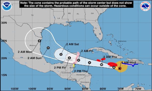
- Graphic credit: National Weather Service
|
Getting your Trinity Audio player ready...
|
The National Weather Service has issued updated forecasts for Hurricane Beryl. While forecasted impacts to Southeast Texas are minimal, Jefferson County Judge Jeff Branick and his office have been monitoring the storm.
“We want people to be prepared,” Branick said. “We’ve been monitoring it ever since it appeared out there.”
As of 11 a.m. Wednesday morning, the storm is a Category Four hurricane with maximum sustained winds of 145 MPH. It is currently in the Caribbean Sea as it nears a potential impact over Jamaica.
Trending
Beryl may continue to weaken over the next few days as it moves into a more hostile environment in the western Caribbean.
Current models predict that Beryl will reach Mexico’s Yucatan Peninsula around 8 a.m. Friday. From there, it will emerge in the Gulf of Mexico late Friday night into Saturday morning.
The NWS says there remains high uncertainty regarding the storm’s eventual track and intensity once it enters the Gulf. Based on current forecasts, effects on Southeast Texas appear limited to minor coastal flooding.
However, things can change quickly and SETX residents should remain vigilant. Continue monitoring official forecasts and review your plans for if the storm were to change course and potentially impact the region.
“I urge people to keep their cars filled with fuel and to have adequate supplies on hand at home,” Branick said.
Visit ready.gov online to ensure you’re prepared for hurricane season and sign up for the Southeast Texas Alerting Network to receive emergency notifications.