Hurricane Beryl expected to bring rain, high tides to SETX
Published 12:41 pm Friday, July 5, 2024
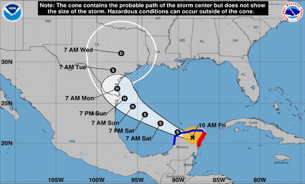
- The forecast of Hurricane Beryl as of Friday at 11 a.m., per the NWS.
|
Getting your Trinity Audio player ready...
|
The latest forecasts for Hurricane Beryl anticipate the storm will cause minimal effects on Southeast Texas. However, there is a higher chance of thunderstorms and heavy rainfall in SETX due to a tropical air mass in place across the region, per the National Oceanic and Atmospheric Administration.
Local officials coordinating with emergency management have been tracking the storm, and its potential effects by the hour.
“We’re involved in office calls with the state and get updates from the National Weather Service daily,” said Port Arthur Deputy Fire Chief Robert Havens.
Beryl made landfall over Mexico’s Yucatan Peninsula Friday morning as a Category 2 hurricane. It weakened to a Category 1 over land, but is expected to strengthen again once it reemerges in the southern Gulf of Mexico.
The forecast track has slowly trended northward and chances favor Hurricane Beryl to make landfall somewhere along the Texas coastline late in the weekend.
Havens said officials anticipate the storm to hit somewhere along the southern Texas coast. As far as effects on Southeast Texas are concerned, he said the region will likely experience rain and elevated tides in coastal areas.
“Other than that, we don’t expect major impact to this area,” Havens said.
Materials from the NWS say rainfall could measure anywhere between two to six inches. Some flash flooding may be possible.
Residents should continue to monitor the latest forecasts for Beryl and have a hurricane plan in place.
The city of Port Arthur is hosting a hurricane preparedness workshop, July 9, from 5 to 7 p.m. at the Bob Bowers Civic Center. Representatives from the NWS, Red Cross, FEMA and local emergency management will be present to help educate people about how to plan for potential storms.