Sunday, Oct 6 update: Latest on Category 1 Hurricane Milton from the National Hurricane Center
Published 12:58 pm Sunday, October 6, 2024
Article first published: Sunday, Oct. 6, 2024, 4 a.m. ET
Article last updated: Sunday, Oct. 6, 2024, 1 p.m. ET
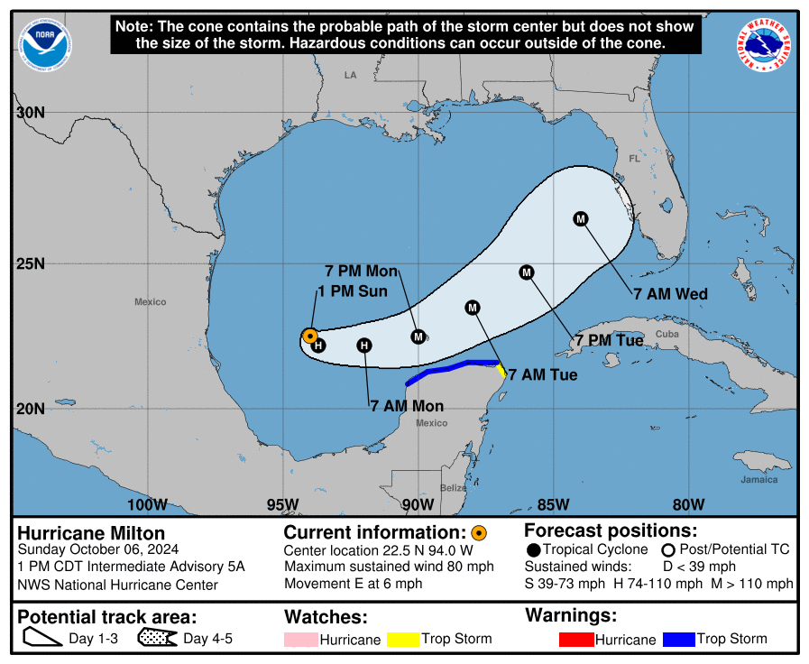
The National Hurricane Center’s 1 pm Sunday advisory reported that the tropical storm Milton had upgraded to a Category 1 hurricane with winds of 80 mph. Category 1 Hurricane Milton is 290 miles west-northwest of Progreso Mexico and 815 miles west-southwest of Tampa Florida, with maximum sustained wind of 80 mph. It’s moving 6 mph to the east.
“… Milton is forecast to move north of the Yucatan Peninsula and to move across the Gulf of Mexico and approach the west coast of the Florida Peninsula by midweek.” forecasters explained. “Milton is forecast to rapidly intensify during the next couple of days and become a major hurricane on Monday.”
Milton found new strength and has evolved from a tropical storm into a Category 1 hurricane with sustained winds of 80 miles per hour.
YESTERDAY (Saturday):
Yesterday (Saturday) at 10 am, the National Hurricane Center published the first advisory for a tropical depression. The weather system gained sufficient intensity to be named Milton when the tropical depression upgraded to a tropical storm with winds of 80 mph.
SUMMARY OF WATCHES AND WARNINGS IN EFFECT:
A Tropical Storm Warning is in effect for:
– Celestun to Cabo Catoche
A Tropical Storm Watch is in effect for:
– East of Cabo Catoche to Cancun
A Tropical Storm Warning means that tropical storm conditions are expected somewhere within the warning area within 36 hours.
A Tropical Storm Watch means that tropical storm conditions are possible within the watch area, generally within 48 hours.
Interests in the remainder of the Yucatan peninsula of Mexico, the Florida Peninsula, the Florida Keys, and the northwestern Bahamas should monitor the progress of this system.
Hurricane and Storm Surge Watches could be required for portions of Florida late today.
HAZARDS AFFECTING LAND:
RAINFALL: Rainfall amounts of 5 to 8 inches, with localized totals up to 12 inches, are expected across portions of the Florida Peninsula and the Keys through Wednesday night. This rainfall brings the risk of locally considerable flash, urban, and areal flooding, along with widespread minor to moderate river flooding with major flooding possible.
Milton will also produce rainfall totals of 2 to 4 inches across portions of the northern Yucatan Peninsula.
For a complete depiction of forecast rainfall associated with Hurricane Milton, please see the National Weather Service Storm Total Rainfall Graphic, available at hurricanes.gov/graphics_at4.shtml? Rainqpf and the Flash Flood Risk graphic at hurricanes.gov/graphics_at4.shtml? Ero.
WIND: Tropical storm conditions are expected in the Tropical Storm Warning area in the Yucatan Peninsula Monday night and Tuesday and possible in the watch area on Tuesday.
SURF: Swells generated by the system are affecting the coast of the southwestern Gulf of Mexico today. These swells are expected to spread northward and eastward along much of the Gulf Coast by early next week, and could cause life-threatening surf and rip current conditions. Minor coastal flooding could also occur along the northern coast of the Yucatan Peninsula from large swells.
Source: National Hurricane Center