Progress report on Tropical Storm Sara: Saturday, Nov 16 update from the NHC
Published 11:56 am Saturday, November 16, 2024

Article first published: Saturday, Nov. 16, 2024, 6 a.m. ET
Article last updated: Saturday, Nov. 16, 2024, 12 p.m. ET
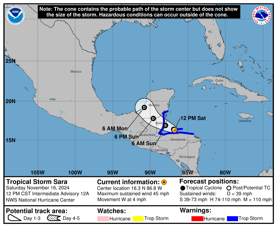
According to the National Hurricane Center’s 12 pm Saturday advisory, Sara after it first crossed the Caribbean Sea and left Honduras and headed to the Caribbean Sea. Tropical Storm Sara is 20 miles west of Isla Roatan Honduras and 125 miles southeast of Belize City, with maximum sustained wind of 45 mph. It’s moving at 4 mph to the west.
“… the center of Sara will move into the Gulf of Honduras this afternoon before approaching Belize tonight.” according to analysts. “Slight fluctuations in intensity are possible tonight and Sunday before landfall in Belize, with weakening expected after landfall.” They also said “Sara is expected to open up into a trough on Sunday night or Monday as it crosses the southern portion of the Yucatan Peninsula.”
Sara after it first crossed the Caribbean Sea, departed Honduras, then moved toward the Caribbean Sea.
YESTERDAY (Saturday):
Yesterday, Sara after it first crossed the Caribbean Sea, moved away from Honduras and advanced into the Caribbean Sea.
SUMMARY OF WATCHES AND WARNINGS IN EFFECT:
A Tropical Storm Warning is in effect for:
– The Northern coast of Honduras from Punta Patuca westward to the Honduras-Guatemala border
– The Bay Islands of Honduras
– The Caribbean Sea coast of Guatemala
– The coast of Belize
– The coast of Mexico from Puerto Costa Maya southward to Chetumal
A Tropical Storm Warning means that tropical storm conditions are expected somewhere within the warning area.
Interests elsewhere in the Yucatan Peninsula should monitor the progress of this system.
HAZARDS AFFECTING LAND:
RAINFALL: Through early next week, rainfall amounts of 15 to 25 inches with isolated storm totals around 35 inches area expected over northern Honduras. This rainfall will lead to widespread areas of life-threatening and potentially catastrophic flash flooding and mudslides, especially along and near the Sierra La Esperanza.
Elsewhere across the rest of Honduras, Belize, El Salvador, eastern Guatemala, western Nicaragua, and the Mexican State of Quintana Roo, Tropical Storm Sara is expected to produce 5 to 10 inches of rain with localized totals around 15 inches through early next week. This will result in areas of flash flooding, perhaps significant, along with the potential of mudslides.
For a complete depiction of forecast rainfall associated with Tropical Storm Sara, please see the National Weather Service Storm Total Rainfall Graphic, available at hurricanes.gov/refresh/graphics_at4+shtml/205755.shtml? Rainqpf#contents
WIND: Tropical storm conditions are expected in the warning area in Honduras through tonight. Tropical storm conditions are expected in Guatemala, Belize, and portions of Mexico beginning later today.
STORM SURGE: Storm surge could raise water levels by as much as 1 to 3 feet above normal tide levels along the immediate coast in areas of onshore winds along the northern coast of Honduras. Near the coast, the surge will be accompanied by large and destructive waves. A storm surge could raise water levels by as much as 1 to 3 feet above ground level near and to the north of where the center of Sara crosses the coast of Belize.
Source: National Hurricane Center


